Pilanesberg Geology

Information & Discussions on Planesberg
Post Reply
User avatar
Toko
Posts: 26619
Joined: Sat May 19, 2012 12:29 pm
Country: -

Pilanesberg Geology

Post by Toko »

http://earthobservatory.nasa.gov/IOTD/view.php?id=86248


Image

Image


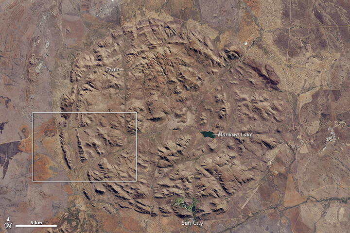
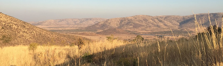
While big game animals such as lions, leopards, elephants, rhinos, and water buffaloes draw most visitors to Pilanesberg National Park, the land these animals live on is just as compelling. Pilanesberg is located in one of the world’s largest and best preserved alkaline ring dike complexes—a rare circular feature that emerged from the subterranean plumbing of an ancient volcano.
The Operational Land Imager (OLI) on Landsat 8 acquired this image of the park in South Africa on June 19, 2015. Seen from above, the concentric rings of hills and valleys make a near perfect circle, with different rings composed of different types of igneous rock. The entire structure sits about 100 to 500 meters (300 to 1,600 feet) above the surrounding landscape. The highest point—Matlhorwe Peak—rises 1,560 meters (5,118 feet) above sea level.
Several streams run through the valleys and faults, though most only flow during the wet season (between October and April). When this image was acquired in June 2015, the streams had run dry. However, man-made dams trap enough water to sustain critical watering holes for the animals. The largest body of water in the park, Mankwe Lake, is visible in the lowlands just east of the center.

Image

Several phases of geologic activity created the landscape over hundreds of millions of years. The process began about 1.3 billion years ago, when primitive organisms like algae were the only lifeforms on Earth and huge volcanic eruptions were common. During this period, magma pooled up near the surface in a large hot spot that bulged with immense pressure. The pressure helped push up a volcanic structure that was several thousand meters tall.
Over time, tubes of magma radiated outward from the main magma chamber beneath the volcano. Eventually this created massive cracks in the Earth’s surface around the volcano at regular intervals. (In cross section, the magma tubes would have looked something like the branches of a tree extending from a common trunk. From above, the radial cracks gave the surface the appearance of a broken window. A good illustration of the magma tubes is available here.) After several violent eruptions sent lava bursting from the volcano, the center collapsed on itself, squeezing even more magma out from the network of cracks.
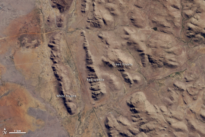
As volcanic activity waned, the remaining magma cooled in the cracks as bands of volcanic rock (mainly syenites and foyaites). Geologists call these structures dikes. The rate of cooling and the composition of the magma affected the type of rock that formed in each dike. For instance, white foyaite has particularly coarse grains and is formed when lava cools slowly. Red syenite forms when magma contains plenty of water. In the detail image, outcrops of white and green foyaite and of red syenite make up the ridges in the southwestern part of the park. These rock types are especially resistant to erosion and weathering, so they were left behind as hills and ridges while streams and glaciers scrapped and scoured away weaker types of rock.

Image

References
Cawthorn, G. et al, (2015, March 6) Pilanesberg National Park, North West Province, South Africa: Uniting economic development with ecological design—A history, 1960s to 1984. Koedoe, 50 (1).
Carruthers, J. (2011, June 30) Geomorphological Evolution of the Pilanesberg. Landscapes and Landforms of South Africa, 39-46.
Jacana Education (2003) Pilanesberg Guide. Accessed July 17, 2015.
NASA Earth Observatory image by Jesse Allen, using Landsat data from the U.S. Geological Survey. Photographs and caption by Adam Voiland.


User avatar
Toko
Posts: 26619
Joined: Sat May 19, 2012 12:29 pm
Country: -

Re: Pilanesberg Geology

Post by Toko »

Concentric circles of rocky hills and valleys in South Africa tell the story of a billion-year-old collapsed volcano in newly released photos from NASA.

The circular Pilanesberg caldera is located in the South African province known as North West, in Pilanesberg National Park. The caldera, or cauldron-shaped crater, features different rings of rock that make up a near perfect circle, with structures that rise about 330 to 1,640 feet (100 to 500 meters) above the surrounding landscape. The tallest point, Matlhorwe Peak, soars 5,118 feet (1,560 m) above sea level.

Several streams typically flow through the valleys of these structures, but the Earth-watching Landsat 8 satellite captured the landscape when it was dry, according to NASA Earth Observatory. Man-made dams trap water for the many animals in the region, and Mankwe Lake, the largest body of water in the park, is located in the lowlands east of the center of the rings. [Photos: The World's Weirdest Geological Formations]

The Pilanesberg's story begins about 1.3 billion years ago, when only very simple organisms, like algae, roamed the Earth and volcanoes frequently spewed magma. This molten rock is created in a large pool (called a "hot spot") just below the Earth's crust. When there's enough of the substance, the pressure rises and magma eventually forces its way through the crust, bursting in a shower of fiery, boiling rock, ash and gas.

After the eruption, the ruptured crust collapses into the magma chamber, similar to how skin subsides after a pimple is popped. Magma remaining underneath the crust is propelled upward, just as pus seeps out from under the skin after a pimple bursts, and floods the landscape as lava. The lava then solidifies into volcanic rocks, which can look dark and glassy (obsidian) or grey and spongy (basalt), and can display other characteristics.

Magma that does not make it to the surface as lava cools and hardens, clogging the cracks inside the Earth. These solidified magma formations are called dikes, and in Pilanesberg, many of the dikes are circular because of the circular cracks. As such, these formations are known as ring dikes, NASA officials said.

This cycle occurred many times during this volcano's active period of about 1 million years, according to NASA. Each time new cracks opened, melted magma erupted and formed different rocks. Tectonic activity, or the movement of continental plates, eventually drifted the volcano away from its hot spot, so Pilanesberg is now dormant, according to NASA Earth Observatory.

In the millions of years since Pilanesberg stopped erupting, erosion from rain, wind and other natural processes removed the volcanic rocks and exposed the inside of the original volcano and its erosion-resistant ring dikes, which are the strangely circular features seen today.

Ring dikes are not common features, NASA said. Only a few such structures are known in the world, including the Ossipee Mountains in New Hampshire. The Ossipee ring dike formed around 90 million years ago, during the second of three major eruptions throughout the active period of the volcano that created the structure. The original volcano was thought to be around 10,000 feet tall (3,048 m), though the region's current highest peak is Mount Shaw, which rises 3,200 feet (975 m) above sea level.

In the Pilanesberg caldera, a valley that resulted from a crack in the Earth's crust (caused by tectonic activity) cuts from the southwest to the northeast of the ring dikes. Life eventually took over the region's circular hills and valleys, morphing the barren rocks into grassy grazing grounds for elephants, buffalos, giraffes, and white and black rhinoceroses, among other creatures.

http://news.yahoo.com/ancient-volcano-t ... 36044.html


User avatar
Flutterby
Posts: 44150
Joined: Sat May 19, 2012 12:28 pm
Country: South Africa
Location: Gauteng, South Africa
Contact:

Re: Pilanesberg Geology

Post by Flutterby »

Thanks Toks, very interesting. \O


Post Reply

Return to “Pilanesberg Game Reserve”